Google Maps with the "terrain" option gives a better appreciation for the land we will be traveling through. For example, this is the pass in southern Colorado that we will climb through on the road to Los Alamos, NM.
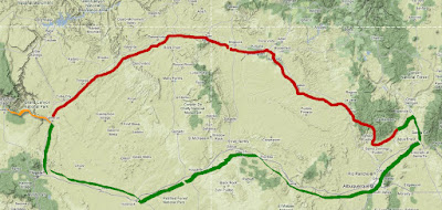
The second day of riding will take us from Bandelier National Monument near Los Alamos to the south rim of the Grand Canyon. I am not certain which of two routes we will take. The southern route (shown in green) is the safer and faster choice. Most of that route is on a modern interstate highway but we could also ride a section of that classic road, Route 66. The more northerly path (shown in red) covers more rugged terrain. I read all of the novels by the late Tony Hillerman whose mystery books were set on the reservation and steeped in Navajo culture and history. It might be more interesting to take the road less traveled and to visit the four corners where Utah, Colorado, New Mexico, and Arizona touch.


1 comment:
WOW.. looks like gorgeous terrain. Safe travels!
Post a Comment